
Rowlett ZIP Code Directory Coverage
The verified Rowlett postal set for research is 75030, 75088, and 75089. Each is a USPS delivery label, not a political boundary. The table identifies the known local evidence and its limit. Use the USPS address lookup for an individual delivery address before treating a ZIP as part of any records search.
| ZIP | Areas Covered | Post Office | Notes |
|---|---|---|---|
| 75088 | Standard Rowlett postal addresses | Rowlett Post Office, 3416 Enterprise Drive | Main standard Rowlett ZIP; delivery geography is not a city boundary. |
| 75089 | Rowlett standard postal area in USPS routing material and the city map | Rowlett-area delivery route | Exact station assignment was not separately identified; verify each address with USPS. |
| 75030 | Rowlett PO Box and mailing evidence | Rowlett Post Office PO Box service | Treat as a mailing or PO Box clue, not a parcel or population boundary. |
Nearby 75087, 75048, 75098, and 75043 belong to Rockwall, Sachse, Wylie, and Garland postal areas in the city-map research. Their proximity does not establish that an address is inside or outside Rowlett. No official source in the research calculated the exact intersection of any ZIP polygon with Rowlett corporate limits.
Rowlett ZIP Codes Do Not Route Records
ZIP is not a county or city-jurisdiction selector. Rowlett is an incorporated city in Dallas and Rockwall Counties, and the city identifies Dalrock Road as the practical county-line reference. An address can carry a Rowlett ZIP yet need a Dallas or Rockwall custodian for a deed, tax account, probate file, court case, or marriage record. The ZIP alone cannot resolve that question.
Use a sequence that respects the local geography: USPS verifies delivery for the full address; Rowlett GIS and the parcel record identify map and boundary context; the appraisal district or tax account confirms the relevant property system; then the correct county clerk holds recorded land documents. Save the account number and legal description. They travel better between portals than a postal label does.
Rowlett ZIP Code 75088
ZIP code 75088 is the main standard Rowlett ZIP identified in the research. The Rowlett Post Office is listed at 3416 Enterprise Drive, Rowlett, TX 75088-9998, with 972-475-4473 and the USPS customer number 800-275-8777. Those details identify a postal service point. They do not define every address that a map, appraisal district, or county clerk will associate with the city.
For an address in 75088, begin with the full street address rather than the ZIP alone. The Dallas CAD address form can search number, street name, city, and a number range. If the parcel is on the Rockwall side, use the Rockwall property route by property location. The result's situs and legal description should control the next research step.
Rowlett ZIP Code 75030
ZIP code 75030 appears in Rowlett as a PO Box and mailing clue. The city itself uses PO Box 99, Rowlett, TX 75030-0099. That evidence supports a postal connection, but it does not make 75030 a land-parcel boundary or a count of people at street addresses. A PO Box route may help interpret correspondence, while property research still starts from the physical situs address.
Do not convert a PO Box label into a street location. Use the full property address in USPS, then locate the parcel through the appropriate CAD or tax search. When an older directory, letter, or deed uses a mailing address, compare its date and legal description before connecting it to a Rowlett parcel.
Rowlett ZIP Code 75089
ZIP code 75089 is also part of the verified Rowlett postal set. It appears in USPS routing material and on the city ZIP map as a Rowlett-area delivery label, but research did not identify a separate station assignment. That is why an individual USPS address result matters more than a broad ZIP assumption. Postal areas can include or border other named places without changing the property custodian.
Historical directories present another limit. Regional telephone and white-page volumes often organize entries by exchange or locality, not by today's ZIP polygons. A name and address in a historical directory can support a family-history trail, yet it does not prove the modern ZIP, legal owner, or current occupant.
Note: USPS delivery verification is address-specific, so verify 75089 one address at a time before starting a county record search.
Find Rowlett Records Within a ZIP
A ZIP code directory can organize the first pass, but the actual searches are address and account based. No dedicated ZIP filter was verified in the DCAD street-address form or the Rockwall property portal. DCAD offers a city dropdown and address range, while Rockwall offers property-location and owner-address modes. That makes a careful address workflow more reliable than claiming a ZIP-wide person list.
- Enter the complete address into the USPS ZIP Lookup to confirm the delivery ZIP and standardized address.
- Open Rowlett GIS to check city, parcel, district, and county context. Record the parcel account or legal description shown by the relevant property source.
- For Dallas-side land, use DCAD city, street, and number-range fields. For Rockwall-side land, use property location in the Rockwall search.
- Use the account and legal description to select the county clerk deed route. A recorded deed is indexed by parties and property terms, not by a ZIP-wide resident list.
- When a ZIP has narrowed the area to a named street, use the Rowlett street directory for the address-by-address record chain.
The Texas basic voter lookup is also not a ZIP-browse tool. It is an individual registration workflow, while a complete voter-file request follows a separate statutory process with restricted fields and use requirements.
Rockwall Property Search Fields
Rockwall-side Rowlett parcels use a different portal path. The search supports property location, owner name, owner address, account, and other portal-defined modes. Its owner address is a mailing address, while property location is the actual situs. The research did not verify a dedicated ZIP filter or an online start year, so use the portal for current account triage, not as a historical ZIP directory.
Dallas has the same practical limit in a different form. DCAD's inspected street-address mode has address number, direction, street name, building, suite, city, and account-type controls, but no dedicated ZIP field. A user can narrow a street with the city selector and a number range, then inspect the result card's situs or mailing ZIP. That is useful for locating an individual parcel after USPS verification. It is not evidence that either county has published a ZIP-wide property or resident search.
| Portal Field | Control | Required? | Verified Use |
|---|---|---|---|
| Search By | Dropdown | Yes | Select account, owner name, owner address, property location, or another defined mode. |
| Search | Text | Yes | Use an account number, owner name, mailing address, or actual property location. |
| Account Type | Dropdown | Optional | Portal-defined account categories. |
| Include Inactive Accounts | Dropdown or radio | Optional | Yes or No. |
| Pay Status | Dropdown or radio | Optional | Both, Paid, or Unpaid. |
The Rockwall property and tax search displays the property-location and account-focused controls used for east-of-Dalrock Rowlett parcels.
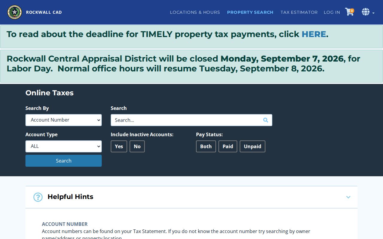
Use property location for the physical parcel and owner address for the tax mailing address. Neither field proves every person who may live at the address, and a recorded instrument should be checked through the county clerk when ownership history matters.
Rowlett ZIP Code Boundary Limits
Postal boundaries and Rowlett city limits are separate shapes. A city-limit parcel can use a neighboring postal-city label, and an address with a Rowlett ZIP can sit outside the incorporated line. The research found no verified exact ZIP-to-city polygon intersection. GIS can provide visual context, but its map layers do not replace an address-specific USPS result or a parcel record.
The surrounding labels make that distinction easy to miss. Rockwall's 75087, Sachse's 75048, Wylie's 75098, and Garland's 75043 appear in the same broader geographic research area. Those names describe postal-city routing, not a finding about incorporation. The same caution applies to a city map label: it can orient the searcher, while the parcel, legal description, and county record establish which custodian should receive a records request.
- ZIP code
- A USPS delivery-area label used to sort mail, not a municipal boundary.
- ZIP+4
- An added four-digit delivery segment that narrows mail routing within a ZIP.
- PO Box ZIP
- A postal label associated with box service, which does not identify a physical parcel.
- Unique ZIP
- A ZIP assigned for a particular organization or special mail arrangement; none was verified as a Rowlett parcel boundary.
- Carrier route
- A USPS delivery sequence within an area, not a public resident roll or county selector.
Limits of a Rowlett ZIP Directory
ZIP code research can confirm a delivery area and make address work more orderly. It cannot produce a verified count of residents, establish ownership, show every household member, or replace county routing. GIS is useful for context, and appraisal accounts are useful for parcel details, but their mailing fields can differ from the situs address. Recorded deeds, when needed, require the correct clerk and legal description.
Texas confidentiality rules also matter. Protected voter information and Address Confidentiality Program information are not ordinary lookup material. If a public record appears wrong, ask the responsible custodian to correct it: the appraisal district for an account, county clerk for a recording index, elections office for registration information, or USPS for delivery formatting. Use public information only for lawful personal purposes and never to harass, intimidate, or harm another person.